


Tour de Guerledan - Jour 2

apa
User
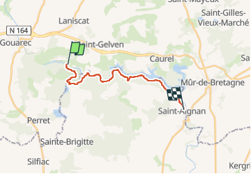

Length
17.3 km

Max alt
235 m

Uphill gradient
428 m
Km-Effort
23 km

Min alt
75 m

Downhill gradient
476 m
Boucle
No
Creation date :
2022-09-04 07:15:56.542
Updated on :
2022-09-04 12:51:38.153
4h50
Difficulty : Very difficult

FREE GPS app for hiking
 SityTrail
IGN / Geographical institutes
SityTrail Plus
The world is yours!
About
Trail Walking of 17.3 km to be discovered at Brittany, Côtes-d'Armor, Bon Repos sur Blavet. This trail is proposed by apa.
Positioning
Country:
France
Region :
Brittany
Department/Province :
Côtes-d'Armor
Municipality :
Bon Repos sur Blavet
Location:
Unknown
Start:(Dec)
Start:(UTM)
490471 ; 5339950 (30U) N.
Comments